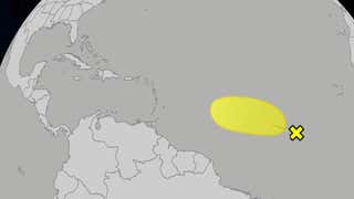
| National Weather Service: Winter Storm Warning |
| | ||||
Kingston, NYCurrent RadarZoom into radar image Zoom into animated radar image |
||||
|
Now Snow will increase in coverage and intensity through the morning commute across Ulster...Dutchess and Litchfield counties. Visibilities will quickly drop back toward 1 mile with accumulations up to 1 inch expected by 8 am. Temperatures will remain between 25 and 30 degrees as northerly winds increase to around 10 mph. | ||||
|
Winter Storm Warning in effect until 1 am EST Thursday... |
||||
|
Today Periods of snow...mainly this afternoon. Snow may be heavy at times this afternoon. Snow accumulation of 4 to 8 inches. Highs in the lower 30s. North winds 10 to 15 mph. Gusts up to 30 mph this afternoon. Chance of snow near 100 percent. Tonight Mostly cloudy. Periods of snow in the evening...then a chance of snow showers after midnight. Areas of blowing snow. Total snow accumulation of 5 to 10 inches. Lows in the mid 20s. North winds 15 to 20 mph with gusts up to 35 mph. Chance of snow 90 percent. Thursday Partly sunny. Highs in the mid 30s. Northwest winds around 15 mph with gusts up to 25 mph. Thursday Night Partly cloudy. Lows around 18. Northwest winds 10 to 15 mph. Friday Mostly sunny. Highs in the lower 30s. Northwest winds 10 to 15 mph. Friday Night Mostly clear. Lows 10 to 15. Saturday and Saturday Night Partly cloudy. Highs in the mid 30s. Lows 15 to 20. Sunday Mostly sunny. Highs in the mid 30s. Sunday Night Partly cloudy. Lows around 15. Presidents Day and Monday Night Mostly cloudy with a 30 percent chance of snow showers. Highs in the lower 30s. Lows 15 to 20. Tuesday Partly sunny. Highs in the mid 30s.
|